Best Hikes in Glacier National Park
Updated October 2026. Checked against NPS.gov. Conditions change, so confirm on the official alerts page before you go.
Short answerThe best hikes in Glacier National Park are the Highline Trail from Logan Pass, Grinnell Glacier and Iceberg Lake in Many Glacier, Avalanche Lake off Going-to-the-Sun Road, and Hidden Lake Overlook at Logan Pass. Day hikes need no permit, but the high trails are usually snow-free only from mid-July to mid-September. Carry bear spray on every trail.

Glacier's best hikes at a glance
The table lists 15 day hikes, from short accessible walks to all-day climbs. Distances are round trip except the Highline, which most people hike one way and finish with a shuttle or second car.
Distances and elevation gain come from the NPS trail pages for each trailhead (updated in 2026) or, where no such page exists, the park's hiking area lists. The newer NPS pages count every climb on the way to the destination, so some gains are higher than older park handouts. Grinnell Glacier, for example, has about 1,600 feet of net gain but 2,596 feet of total climbing on the way up. Times are typical for an average hiker with stops.
| Hike | Round trip (mi) | Elevation gain (ft) | Difficulty | Time | Best season |
|---|---|---|---|---|---|
| Trail of the Cedars | 0.7 | 83 | Easy | 30 min | Late May to mid-October |
| Running Eagle Falls | 0.6 | 47 | Easy | 20-30 min | June to early September |
| Swiftcurrent Lake Loop | 2.6 | 258 | Easy | 1-1.5 hr | June to September |
| St. Mary and Virginia Falls | 3.6 | 285 | Easy | 2 hr | Late June to mid-October |
| Apikuni Falls | 1.6 | 651 | Moderate | 1-1.5 hr | June to September |
| Hidden Lake Overlook | 2.6 | 608 | Moderate | 1.5-2 hr | Mid-July to mid-September |
| Hidden Lake (lakeshore) | 5 | 639 | Moderate | 3-4 hr | Mid-July to mid-September |
| Avalanche Lake | 4.6 | 741 | Moderate | 2.5-3 hr | June to mid-October |
| Apgar Lookout | 7.2 | 1,966 | Moderate | 4 hr | June to October |
| Iceberg Lake | 9.6 | 1,765 | Moderate | 5-6 hr | July to September |
| Scenic Point | 7.8 | 2,350 | Strenuous | 4-5 hr | July to early September |
| Siyeh Pass | 9.2 | 2,362 | Strenuous | 5-6 hr | Mid-July to mid-September |
| Grinnell Glacier | 10 | 2,596 | Strenuous | 6-8 hr | Mid-July to mid-September |
| Ptarmigan Tunnel | 10.6 | 2,300 | Strenuous | 6-7 hr | Mid-July to late September |
| Highline Trail, Logan Pass to The Loop (one way) | 11.8 | 2,388 | Strenuous | 6-8 hr | Mid-July to mid-September |
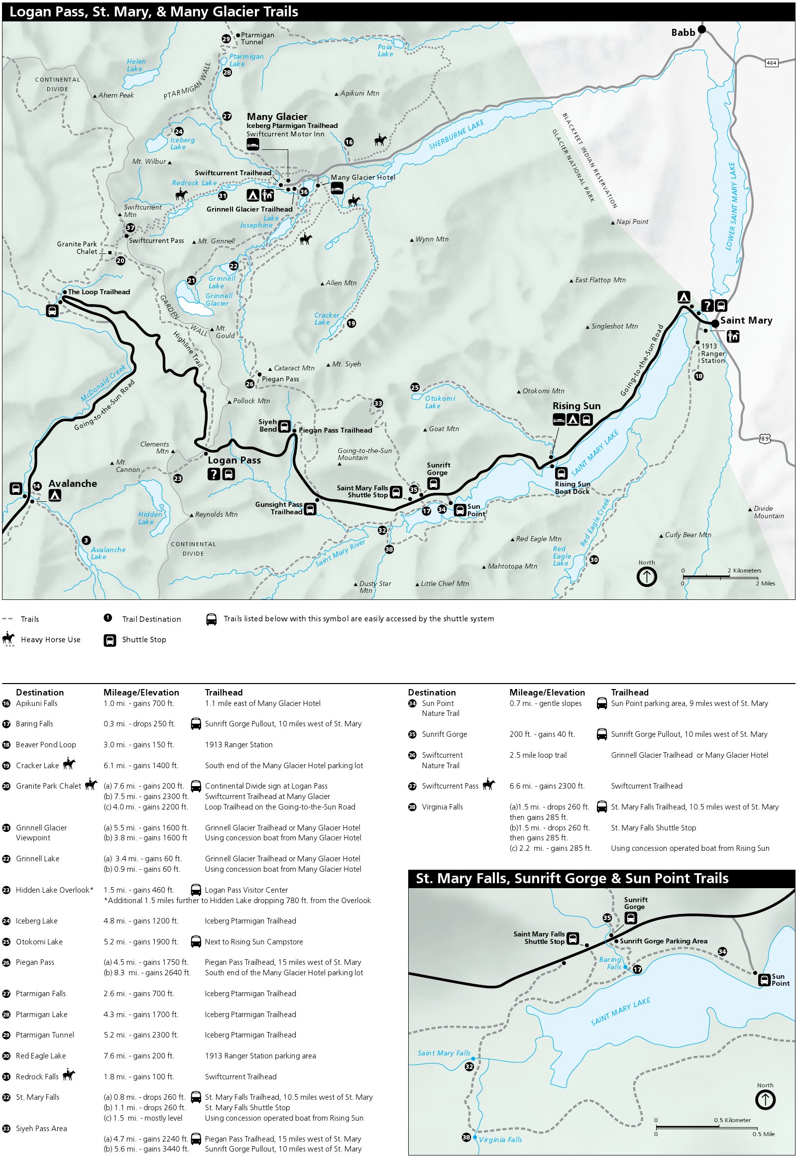
Easy and family-friendly hikes
Trail of the Cedars is a 0.7-mile boardwalk loop through old western red cedars and hemlocks at Avalanche Creek, about 16 miles up Going-to-the-Sun Road from West Glacier. NPS lists it as wheelchair accessible. Parking at Avalanche fills early in summer, and the 2026 park shuttle did not stop here, so arrive before 8 a.m. or late in the day.
Swiftcurrent Lake Loop is a 2.6-mile walk around the lake in front of Many Glacier Hotel, with views of Grinnell Point and Mount Gould. Running Eagle Falls, at the entrance to the Two Medicine valley, is a 0.6-mile round trip to a waterfall that pours out of a cliff face.
St. Mary and Virginia Falls is the best easy waterfall hike on the east side. From the St. Mary Falls Trailhead it is 1.2 miles to St. Mary Falls and 1.8 miles to Virginia Falls, each way. The trail drops about 260 feet first, so the climb comes on the way back. A concessioner boat from Rising Sun offers another way in (fees apply).
Logan Pass: Hidden Lake and the Highline Trail
Logan Pass sits at 6,646 feet on the Continental Divide, and both of its trails usually stay under snow until July. NPS says it cannot predict when the Logan Pass trails will open, and the Highline can stay closed for hazardous snow after the road opens.
Hidden Lake Overlook is 1.3 miles each way from the visitor center, mostly on boardwalk and packed trail, with about 600 feet of climbing. Mountain goats and bighorn sheep are common near the trail. Continuing 1.2 miles to the lakeshore means a 780-foot descent that you climb back out on the return.
The Highline Trail runs 11.8 miles one way from Logan Pass to The Loop, with 2,388 feet of gain and 4,773 feet of loss. It follows the Garden Wall, a cliff band below the Continental Divide, and passes Granite Park Chalet at about mile 7.6. NPS warns that much of the trail is exposed. The first stretch is a narrow ledge above Going-to-the-Sun Road with a hand cable, so it is not for anyone uneasy with heights.

2026 Logan Pass parking and shuttle rules
Glacier dropped vehicle reservations for 2026. Instead, from July 1 through Labor Day (September 7, 2026), private vehicles could park at Logan Pass for three hours at most, with no overnight parking except for backcountry permit holders and Granite Park Chalet guests. NPS said three hours is enough for Hidden Lake Overlook.
Hikers doing the Highline to Granite Park Chalet or The Loop needed a ticket for the express shuttle. Tickets cost a $1 Recreation.gov processing fee, were required for everyone age 2 and older, and were sold only online or by phone (877-444-6777), not in the park. Part went on sale 60 days ahead on a rolling basis starting May 2, and the rest were released at 7 p.m. Mountain time the evening before. West-side shuttles left from Apgar and Lake McDonald Lodge, east-side shuttles from St. Mary Visitor Center and Rising Sun, and the shuttles did not serve Avalanche Lake or Trail of the Cedars.
Both programs ended for the year on September 7. NPS called them a pilot and has not announced the 2027 plan; the 2026 rules were announced on February 18, 2026, so expect 2027 details in late winter. Going-to-the-Sun Road over Logan Pass usually closes for the winter on the third Monday in October (October 19 in 2026), and snow can close it sooner.
Avalanche Lake and the Lake McDonald area
Avalanche Lake is the most popular hike on the west side: 2.3 miles each way through cedar and hemlock forest along a gorge, ending at a lake ringed by cliffs with several waterfalls. The trail starts from Trail of the Cedars at Avalanche Picnic Area. Expect crowds midday in July and August, and keep to the trail along the slippery gorge edges.
For a quieter climb, Apgar Lookout gains almost 2,000 feet in 3.6 miles to a fire lookout with a view up Lake McDonald. It starts near West Glacier, so it is reachable even when the upper road is closed.
Many Glacier: Grinnell Glacier, Iceberg Lake and Ptarmigan Tunnel
Many Glacier, on the northeast side, has the park's densest set of big day hikes and some of its best grizzly habitat. It no longer needs a vehicle reservation, but NPS may temporarily close the road to new vehicles when lots fill. Arrive early.
Grinnell Glacier is 5 miles each way to the viewpoint above the glacier and Upper Grinnell Lake. Taking the concessioner boats across Swiftcurrent Lake and Lake Josephine cuts 1.3 miles each way (book tickets in advance). The upper trail crosses steep slopes and can hold snow into July.
Iceberg Lake is 4.8 miles each way to a cirque lake under a 3,000-foot wall, where ice often floats into midsummer. Ptarmigan Tunnel shares the same trailhead, then climbs to a 1930s tunnel through the Ptarmigan Wall. NPS says the tunnel doors are generally open from mid-July to late September. Apikuni Falls, a steep 0.8 miles each way, is the short option here.


Two Medicine and Siyeh Pass
Scenic Point climbs 2,350 feet in 3.9 miles above Two Medicine Lake onto open, windy slopes with views east across the plains. Two Medicine had major construction in 2026: the campground was closed all year, the North Shore Trailhead was not accessible, and the road closed at the Running Eagle Falls Trailhead on September 8, with the closure moving to the Highway 49 junction later in September. NPS expects road work to be finished in late 2027 but says it may continue into 2028, so check the park's construction page before planning a Two Medicine hike.
Siyeh Pass, from Siyeh Bend on Going-to-the-Sun Road, climbs 2,362 feet in 4.6 miles past Preston Park meadows to a pass at about 8,000 feet. Many hikers continue down to Sunrift Gorge as a point-to-point hike, which needs a shuttle or second car.
Hiking safety, bears and wildlife rules
Glacier has both grizzly and black bears. NPS says bear spray is the most effective deterrent: carry it where you can reach it and know how to use it. Hike in groups (NPS reports no attacks on groups of four or more), call out and clap regularly, since bells are not enough, and do not run on trails. Be most alert near streams, in thick brush, at blind corners, in berry patches, and at dawn and dusk.
You must stay at least 100 yards from bears and wolves and 25 yards from all other wildlife, including the mountain goats at Logan Pass. Never leave food or scented items unattended, even in a pack at a viewpoint.
Weather changes fast at Logan Pass and on high passes. Snowfields linger into summer above steep drops, and stream water must be treated before drinking. Pets are not allowed on park trails.
- Bear spray on your hip, not in your pack
- Rain jacket and warm layer, even in August
- More water than you think, plus a filter or tablets
- Map and a downloaded trail map; cell service is limited
- Sturdy boots with traction for snow patches
- Sun protection; much of the high country is open
- A shuttle ticket or second car for one-way hikes
Permits, accessible trails and current conditions
Day hikes in Glacier do not require a permit. Any overnight trip in the backcountry needs a wilderness permit; see our camping guide for the lottery and walk-up system.
For accessible options, NPS lists Trail of the Cedars as wheelchair accessible, Running Eagle Falls as accessible to a viewing area of the falls, and two sections of the Swiftcurrent Lake trail (0.9 miles from Many Glacier Hotel and 0.75 miles from the picnic area). The paved Apgar bike path is mostly level for 1.5 miles, and NPS says all park shuttles are wheelchair accessible.
Check the park's Trail Status Reports page the morning you hike. As of its late-August 2026 update, trails in the Walton, Coal Creek and Nyack areas had many downed trees, and NPS notes backcountry campgrounds can close at any time for bear activity or fire.
Common questions
What is the most famous hike in Glacier National Park?
The Highline Trail from Logan Pass. It runs 11.8 miles one way along the Garden Wall to The Loop, with Granite Park Chalet along the way.
Do I need a permit or reservation to hike in Glacier?
No permit is needed for day hikes. In 2026 there were no vehicle reservations, but Logan Pass had a 3-hour parking limit and a $1 shuttle ticket from July 1 to September 7. Overnight trips need a wilderness permit.
When are Glacier's high trails open?
Usually mid-July to mid-September. Snow often covers Logan Pass and Many Glacier trails into July, and early snow can arrive in September.
What is a good easy hike in Glacier?
Trail of the Cedars (0.7-mile accessible loop), Running Eagle Falls, Swiftcurrent Lake Loop, or St. Mary and Virginia Falls.
Do I really need bear spray?
Yes. Grizzlies live throughout the park, and NPS calls bear spray the most effective deterrent. Carry it on every trail.
Plan and book
Some links below are affiliate links. If you book through them, we may earn a commission at no extra cost to you. How this works
Where to stay
Tours and activities
- Guided tours on Viator (opens in a new tab)Day trips, wildlife, photography
- Tours on GetYourGuide (opens in a new tab)Compare options and reviews
- Campsites on Recreation.gov (opens in a new tab)Official federal booking site
What to pack for Glacier
- Bear sprayEssential in one of the densest grizzly areas in the lower 48.
- MicrospikesSnowfields linger on high trails into July.
- Rain shellWeather changes quickly at Logan Pass.
- BinocularsFor mountain goats and bighorn sheep.
- Warm layersExpect cold mornings even in August.
More Glacier guides
- Best Time to Visit Glacier National ParkWhen to visit Glacier National Park, month by month: Going-to-the-Sun Road opening dates, snow, wildfire smoke, crowds, fall color and what is open in winter.
- Going-to-the-Sun Road Guide: Reservations, Shuttle and Best StopsPlan your Going-to-the-Sun Road drive in Glacier: 2026 access rules, Logan Pass parking limit, shuttle tickets, size limits, opening dates and top stops.
- Camping in Glacier National Park: Campgrounds, Reservations and TipsAll 13 Glacier National Park campgrounds: sites, 2026 seasons, Recreation.gov reservations, first-come sites, RV limits, wilderness permits and closures.
Sources
- NPS: Glacier National Park Announces 2026 Summer Operations
- NPS: Highline Trailhead
- NPS: Hidden Lake Trailhead
- NPS: Grinnell Glacier Trailhead
- NPS: Iceberg Lake Trailhead
- NPS: Avalanche Lake Trail
- NPS: Trail of the Cedars
- NPS: Swiftcurrent Lake Trail
- NPS: Running Eagle Falls Trailhead
- NPS: Apikuni Falls Trail
- NPS: Siyeh Bend
- NPS: Apgar Lookout Trailhead
- NPS: Hiking Many Glacier
- NPS: Hiking St. Mary
- NPS: Hiking Two Medicine
- NPS: Hiking Lake McDonald
- NPS: Trail Status Reports
- NPS: Road Construction and Infrastructure Project Work
- NPS: Bear Safety
- NPS: Accessibility
- NPS: Glacier Maps
- NPS: Alerts and Conditions